Introduction
Walk onto any well-run event site and you will usually find the same thing tucked under the arm of the Site Manager, pinned to a production office wall or folded into the pocket of a Safety Advisor’s jacket: a grid map.
It looks simple. A site plan with a grid laid over the top, dividing the space into lettered and numbered blocks.
But that simple overlay is one of the most powerful tools available through build, show and break
Grid maps turn large, complex environments into something manageable. Teams stop guessing where things are and start knowing.
Bringing Order to Big, Busy Environments
Large event sites are sprawling, constantly moving environments.
Infrastructure goes up and down, vehicles move continually, and dozens of contractors work across wide areas. Without a common reference system, trying to direct people to specific locations becomes slow and unnecessarily complicated.
A grid map solves this instantly.
Instead of instructing someone to “head to the second tower beyond the VIP entrance, near the tree line”, you can say, “Go to C4”. That’s a real difference in clarity.
The grid creates a shared shorthand that everyone can understand, regardless of their familiarity with the site.
Rupert Bassadone, founder of Event Site Design, puts it well – ‘understanding and being able to use grid maps is a fundamental skill. In a world that relies heavily on GPS, grid maps remain a dependable fallback when technology fails.’
We’ve worked with Rupert’s team on multiple events and the grid map is always one of the first things they produce.
This matters most during high-pressure situations, such as when a delivery lorry is stuck, a contractor needs direction, or work has to stop in a specific zone. Grid references remove the potential for misinterpretation.
Enhancing Safety Through Faster, Clearer Communication
From a safety perspective, grid maps provide a huge advantage.
On event sites, speed of communication often correlates directly with risk reduction. If teams cannot quickly locate hazards, people or plant, delays can allow situations to escalate.
Grid maps allow safety teams to:
-
-
- point medical teams at the exact spot
- isolate active work zones without ambiguity
- support emergency services who don’t know the site
- coordinate traffic management across the site
-
Instead of vague references to ‘the left side of the stage compound’ or ‘near the cabins behind the arena’, a grid reference provides certainty. Dublin Fire Brigade, for example, always requests a grid map for our events in the city. They may need to respond to an emergency call at the event and they won’t be as familiar with the layout as those who are working on it every day. For them, the grid map is a vital element of their operational plan.
When something goes wrong, seconds matter. Having a shared reference stops people having to describe where they are while everyone else is trying to act on the information.
Speaking the Same Language
Event sites bring together people with very different backgrounds and levels of site familiarity.
Crew, contractors, artists, suppliers, emergency responders, volunteers and management all operate within the same footprint but do not always share the same mental map of the space.
It gives newcomers a fighting chance to navigate confidently and helps experienced crew communicate more consistently. For international teams like the ones we worked with on Aravia in Qatar, or contractors arriving late in the build, the grid becomes an equaliser.
With everyone on the same grid, radio traffic cuts down and the site runs faster.
How to Build a Grid Map for Your Event Site
Creating a grid map is straightforward, but a few key decisions will determine whether it actually works under pressure.
Start with an Accurate Site Plan
Start with your site plan, ideally a scaled CAD drawing, but even a clear aerial image or OS map will work for smaller events. The grid is an overlay, so the base map needs to be accurate first.
Divide the Site into Letters and Numbers
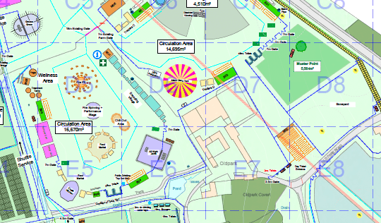
Divide the site into a grid using letters along one axis and numbers along the other. A1 is your top-left square, and the grid reads like a spreadsheet. Keep it consistent. Letters always run left to right, numbers always run top to bottom.
Orient North at the Top
North should be at the top of the map, aligned with the site plan. If your grid doesn’t match the orientation of the site plan your teams are already using, you’ve created confusion rather than solved it.
Choose Your Grid Square Size
Grid square size depends on your site. For a compact urban event, 25m x 25m squares might give you the precision you need. For a large greenfield festival site, 50m x 50m or even 100m x 100m might be more practical. You want enough resolution to be useful on the radio but not so many squares that people can’t remember where they are.
Use Layered Grids for City-Scale Events
On a city-scale event like Dublin Pride, where we worked with Rupert Bassadone and Event Site Design, one grid wasn’t enough. They built an overview grid covering the full route across the city, then created separate local area grids for key locations i.e. the main stage area, the assembly point, the dispersal zone using secondary letter / number codes at a finer scale.
That layered approach meant the event management team could work from the overview while ground teams had the detail they needed for their specific zones.
Distribute the Map
Label every grid square clearly on every copy of the map. Print multiple copies for the production office wall, for the safety team, for every radio operator, for the emergency services liaison. If it only exists on one person’s laptop, it’s useless when you need it most.
Walk the Grid Before the Build
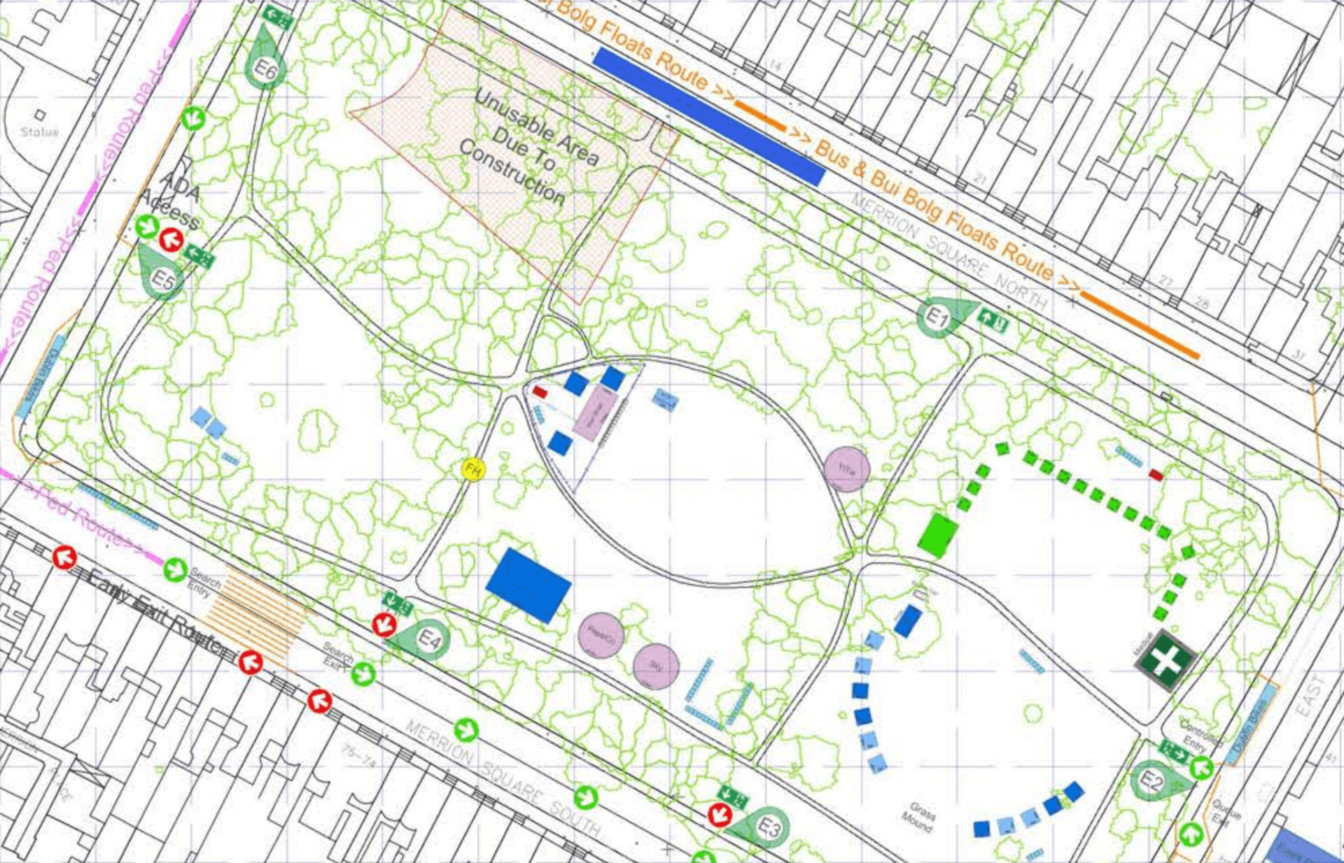
One thing we always do is we walk the grid before the build starts and check that the grid references make sense on the ground.
A grid square that looks logical on a map might span two completely different areas on the ground a fence line, a level change, or a structure that nobody had built when the plan was drawn can split what appears to be one zone into two.
If a grid reference could mean two different places depending on which side of a barrier you’re standing on, split the square or adjust the boundary.
Supporting Better Planning and Site Management
Grid maps are not only useful during live operations.
They play an important role in pre-planning and logistical design. Breaking a site into manageable blocks allows planners to allocate contractors, schedule deliveries and coordinate overlapping works more effectively.
For example:
-
-
- crane operations separated by zone
- plant routes agreed in advance against the grid
- waste management sweeping systematically zone by zone
- emergency access routes mapped and tested before the event
-
Using the grid as a logical framework helps planners and managers visualise workload distribution and identify pinch points before they arise.
More Efficient Workforce and Vehicle Deployment
Whether you are directing a welfare team to restock cabins, sending a telehandler to relocate barriers or coordinating routine inspections, grid maps reduce ambiguity.
Crew can be dispatched quickly, supervisors know exactly where resources are deployed, and vehicle movements become more intentional.
During busy peak times, when multiple requests compete for attention, the grid ensures that tasks are prioritised and routed efficiently.
An Indispensable Tool for Emergencies
Emergencies are where grid maps earn their keep. In an incident, the speed and clarity of communication can influence outcomes.
Emergency services often ask for exact locations, and a grid map allows on-site teams to provide them instantly.
Medical responders go straight to the right spot. Crowd density concerns surface in seconds rather than minutes.
Without a grid reference, teams may spend precious time trying to describe locations verbally or physically searching, which can delay response.
Why We Use Grid Maps on Every Project
Grid maps aren’t glamorous and they aren’t the most sophisticated piece of kit on any event. They’re just one of the highest-impact-per-effort things we do.
A grid map may look like a small detail, but in practice it is one of the most important operational tools on any major site.
It ensures that teams speak the same language, hazards are identified quickly, emergency responses are faster, and routine operations run with less confusion and delay.
At Safe Events Global, we consider grid mapping an essential part of event planning and delivery. It costs almost nothing to produce and it makes everything on site work better i.e. safety, logistics, comms, the lot.
Whether your event spans a compact urban footprint or hundreds of acres of greenfield land, a grid map turns complexity into clarity.
FAQ
Q: What is a grid map for an event site?
A grid map is a site plan with a lettered and numbered grid overlay that divides the event space into clearly defined squares. Every location on site gets a unique reference, like C4 or F7, so that teams can communicate positions quickly and precisely over radio, in briefings, and during emergencies.
Q: How do you decide what size grid squares to use?
It depends on the scale of the site. For a compact urban event, 25m x 25m squares usually give enough precision. For a large greenfield festival, 50m x 50m or 100m x 100m works better. The test is whether a grid reference is specific enough to direct someone to the right place over radio without needing further description.
Q: Do emergency services use event grid maps?
Yes. In our experience, services like Dublin Fire Brigade actively request grid maps for events in the city. A grid map gives responding crews, who may never have been on the site before, a way to locate incidents immediately using the same references the on-site teams are using.
Q: Can one grid map cover a large or city-wide event?
For city-scale events, a single grid usually isn’t detailed enough. The approach we’ve used on events like Dublin Pride is to create an overview grid covering the full footprint, then produce separate local area grids at a finer scale for key zones like the main stage, assembly points, and dispersal areas. Ground teams work from the local grids while event management uses the overview.
Q: When should a grid map be created during event planning?
As early as the site plan is confirmed. The grid needs to be in place before the build starts so that every contractor briefing, safety induction, and delivery schedule can reference it. Producing a grid map the day before the event means most of the people who needed it during the build never had it.